3D Workspace
Home
Assets
Affiliate Program
Creator Program
Sign up/Log in
View Plans
DCC Bridge
王思祥
01-30 08:42
Model Name
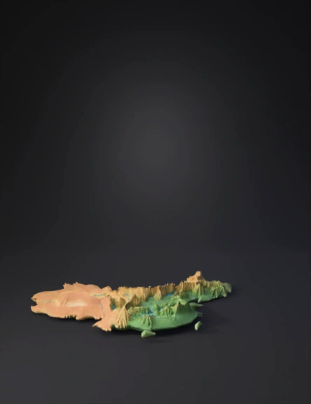
topographic map 3d model
Tags
nature environment
nature environment realistic
nature environment rendering
nature environment rendering realistic
realistic
rendering
rendering realistic
terrain
topographic map
Prompt
An ultra-realistic, ultra-high-definition 3D topographic composition showing THREE separate city maps with PERFECTLY MATCHING BORDERS that can seamlessly connect: Kunming City (top/north), Yuxi City (middle/center), and Honghe Prefecture (bottom/south), all from Yunnan Province, floating against a pure pitch black background. 45-degree isometric bird's-eye view perspective from above. CRITICAL BORDER ALIGNMENT: The three maps are arranged vertically with their shared borders EXACTLY ALIGNED so they can perfectly tile together: - Kunming's southern border matches Yuxi's northern border precisely - Yuxi's southern border matches Honghe's northern border precisely - The borders where they meet are IDENTICAL to allow seamless connection Each map shows only natural terrain with NO buildings, NO urban structures, NO cities - purely geographical features. KUNMING CITY MAP (TOP/NORTH POSITION): Northern section showing Kunming's administrative boundaries. Central Kunming Basin (Kunming Bazi) with natural grasslands and agricultural fields, Dianchi Lake prominent in southwest with azure blue water surface and realistic reflections, Western Hills (Xishan) mountain range along western shore of Dianchi with densely forested slopes and rocky peaks, Changchong Mountain in north with rolling hills covered in vegetation, Jiaozi Snow Mountain in northeast with snow-capped peaks and glaciers (high altitude snow remains in summer), Yangzong Lake in east with clear turquoise water, Stone Forest (Shilin) karst formations in southeast with grey limestone pillars, Panlong River and tributaries winding through valleys, lush green forests covering all mountain slopes in various shades from deep emerald to bright green, terraced agricultural fields, valleys with streams, wetlands around lake shores. Summer season with vibrant peak-growth vegetation, forests thick and full, mature green crops on terraces. Southern border of Kunming CLEARLY DEFINED to match Yuxi's northern border. YUXI CITY MAP (MIDDLE/CENTER POSITION): Central section positioned directly south of Kunming with EXACT BORDER ALIGNMENT. Northern border PRECISELY MATCHES Kunming's southern border. Fuxian Lake - China's second deepest lake - prominent in north-central area with crystal clear turquoise-blue water showing exceptional transparency, Xingyun Lake in center area, Qilu Lake in southwest with wetlands, Ailao Mountain range running north-south along western boundary with multiple forested peaks, Yuanjiang River valley in west creating elevation drop, Hongta Mountain in north-central region with distinctive red rock formations, rolling hills and basins throughout central and eastern areas, agricultural terraces on hillsides (tobacco and rice terraces showing summer green crops), natural grasslands, pine forests at higher elevations, broadleaf forests mid-elevations, bamboo groves in valleys, exposed red soil around Hongta Mountain, wetland vegetation with reeds around lake shores, streams feeding the three lakes. Summer season with lush vegetation, clear reflective lake surfaces. Southern border CLEARLY DEFINED to match Honghe's northern border. HONGHE PREFECTURE MAP (BOTTOM/SOUTH POSITION): Southern section positioned directly south of Yuxi with EXACT BORDER ALIGNMENT. Northern border PRECISELY MATCHES Yuxi's southern border. Red River (Honghe/Yuan River) valley creating dramatic deep gorge landscape with steep cliffs, Ailao Mountain range continuation along western areas with high peaks, Yuanyang terraced rice fields with water-filled paddies creating spectacular mirror reflection patterns covering hillsides in geometric patterns, tropical and subtropical vegetation in southern lowlands with dense forests, extensive karst formations with limestone peaks and valleys, deep river valleys and steep mountains, Gejiu area mountains (natural terrain only), Mengzi Basin with flat valley floor, numerous rivers and tributaries creating water network, lush forests at various elevations, bamboo forests, exposed red soil characteristic of the region. Summer season with vibrant green vegetation, water-filled terraces reflecting sky. ALL THREE MAPS NATURAL LANDSCAPES ONLY: Dense forests in multiple shades of green covering mountains, water bodies in blues and turquoises (lakes, rivers, streams), mountain ranges with accurate elevation relief and topography, agricultural terraces following natural contours, karst limestone formations, extensive river systems, wetlands, valleys, peaks, NO buildings, NO urban structures, NO cities - purely natural terrain and landscape elements. SUMMER SEASON ATMOSPHERE across all three maps: Vibrant lush green vegetation at peak growth, forests at maximum density appearing thick and full, bright emerald to deep forest green colors, agricultural terraces showing mature green crops, clear water in all lakes and rivers reflecting summer sky, realistic summer landscape characteristics while maintaining terrain authenticity. CINEMATIC LIGHTING consistent across all three maps: Dramatic directional sunlight creating strong shadows on mountain slopes and in valleys, rim lighting on mountain ridges and peaks highlighting topography, atmospheric haze in distant mountains creating depth, brilliant sunlight reflecting off water surfaces (especially crystal-clear Fuxian Lake) creating bright focal points, deep shadows in gorges and valleys against pure black background creating powerful contrast, golden hour lighting quality emphasizing terrain relief and water clarity. VIBRANT COLORS against pure black background: Multiple rich shades of green from forests and vegetation, stunning azure blue Dianchi Lake, crystal turquoise-blue Fuxian Lake, lighter blue-green Xingyun Lake, grey-blue Qilu Lake, turquoise Yangzong Lake, blue rivers and streams, grey and white limestone karst formations, red-brown exposed soil and rock formations (Hongta area and Honghe region), golden-green agricultural terraces, colorful wildflower patches, brown and grey mountain rock faces, white snow on Jiaozi Mountain, all natural earth tones creating rich palette against pure black. PHOTOREALISTIC TEXTURES: Mountain rock geology with stratification and erosion patterns, forest textures with individual tree crowns visible, exceptional water clarity in Fuxian Lake showing depth and transparency, water surfaces with realistic reflections and ripples, agricultural terrace soil patterns, wetland vegetation textures, karst limestone with detailed features, accurate representation of each region's unique geography. MAP COMPOSITION: The three maps are clearly separated as distinct regions but their shared borders are PERFECTLY ALIGNED and IDENTICAL where they meet, allowing them to seamlessly tile together as one continuous geographic region from north (Kunming) through center (Yuxi) to south (Honghe). Map boundaries clearly visible against pure black background. Vertical arrangement showing geographic progression from plateau lakes in north to terraced mountains in south. TECHNICAL SPECIFICATIONS: 8K resolution ultra-high-definition quality, professional cartographic precision ensuring perfect border matching for seamless tiling capability, National Geographic nature documentary quality, octane render level detail, extreme natural detail precision, 16:9 widescreen format showing all three maps in vertical north-to-south arrangement, suitable for creating continuous regional geographic visualization.
Detailed Info
Related Models
Enter invite code
Enter invite code to get credits!
 王思祥
王思祥


 王思祥
王思祥