3D Workspace
Home
Assets
Affiliate Program
Creator Program
Sign up/Log in
View Plans
DCC Bridge
deepikamohan0011
09-28 15:45
Model Name
outdoor sensor node 3d model
Tags
camera mast
machine
machine realistic
machine rendering
machine rendering realistic
realistic
rendering
rendering realistic
sensor mast
sensor module
solar
Prompt
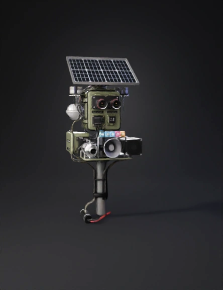
This system employs a network of multi-modal IoT sensors including high-resolution ESP32 CAMERA and infrared cameras capable of capturing day and night elephant movements across a wide field of view. Complementing the visual sensors, vibration sensors like Geophone SM24 detect elephant footsteps by sensing seismic vibrations, while specialized acoustic sensors such as the AudioMoth device capture elephant vocalizations, enhancing detection accuracy by confirming presence through elephant calls. These sensors provide continuous data streams to edge computing platforms like Raspberry Pi 5 , which locally run AI models, notably YOLOv8 or EfficientDet, to identify elephants by processing images, video, and audio data with low latency to minimize false alarms. Integration of GPS modules facilitates precise real-time localization of elephants and sensitive locations such as villages, roads, and waterholes, allowing the system to calculate distance and bearing from detected elephants to these key points. Environmental sensors measuring temperature, humidity, and rainfall contribute contextual data that AI models use to predict elephant behavior and migration likelihood towards crops or water sources, enhancing the predictive capability of potential conflict events. Upon detection of elephants entering critical ranges near human settlements, the system automatically activates a suite of non-harmful deterrents, including ultrasonic bee sounds, high-powered chili smoke generators, flashing strobe lights, and directional fans, all coordinated through a pan-tilt motorized mount to target the elephant’s path for effective redirection. This rapid deterrent activation occurs within seconds of detection, ensuring maximum preventive impact. The entire system operates on solar-powered, battery-backed hardware designed for rugged continuous operation in rural and forest environments, with communication enabled via LoRaWAN, GSM/4G modules to transmit alerts and data streams to a centralized cloud-based dashboard. This dashboard, accessible via web and mobile apps, provides forest officials with live video feeds, GPS-mapped elephant locations, environmental data, and AI-driven predictive analytics such as hotspot identification, migration routing, and conflict probability alerts. Real-time notifications through SMS, emails, and sirens ensure immediate action by both local communities and forest departments. Historical data is securely stored locally and in the cloud for long-term analysis, enabling machine learning models to evolve and improve detection accuracy and hotspot forecasting over time. Scalability is built into the system architecture, allowing expansion to other conflict-prone states, promoting data-driven conservation strategies aligned with sustainable development goals.
Detailed Info
Related Models
Enter invite code
Enter invite code to get credits!